What’s the Intercity Cycleway?
The Intercity Cycleway goes from the Regatta Grounds just north of the Hobart CBD and continues for ~15km north through Glenorchy to Claremont. It’s arguably the best bike infrastructure in Hobart and is heavily used by both recreational & commuter riders. Since it’s smooth, flat and crosses relatively few roads, it’s a popular ride with young kids. Despite being called a cycleway, it’s a shared path and is also very popular with walkers & runners.
What’s the issue?
Although the Intercity Cycleway is among the best bike infrastructure in Hobart it’s far from perfect. One of the biggest issues is the poor design of the road crossings. Most if not all the crossings need to be made safer but the crossing at Queens Walk is the standout and makes an excellent case study. Of note it’s a heavily supported unsafe spot on BikeSpot which you can read about here.
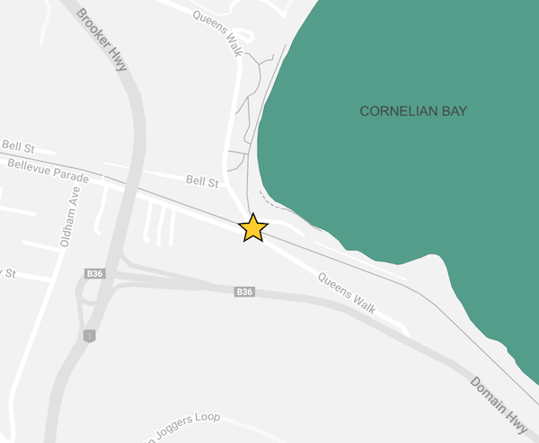
The crossing
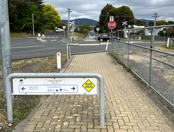
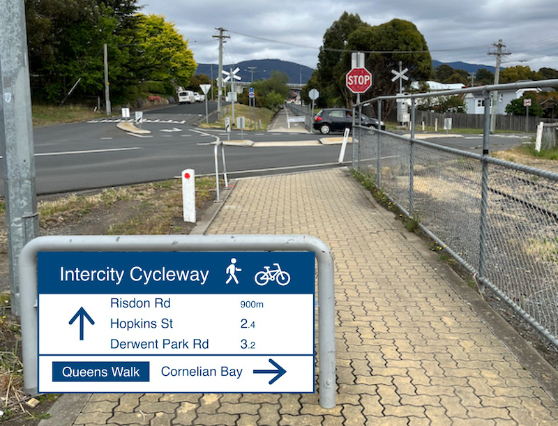
Approaching the crossing on the Cycleway, the Stop sign indicates that those walking & riding must yield to cars.
There is a change in texture of the pavement & a partially obstructive barrier all aimed at warning the walkers & riders that there’s a road ahead.
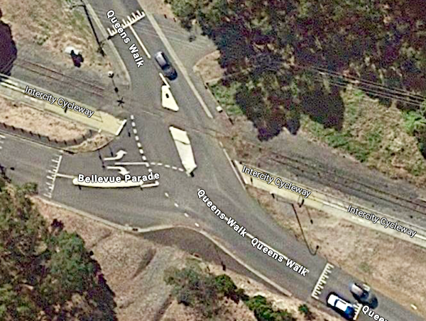
Approaching in a car is a different matter. There’s no change in colour, texture or height of the pavement to suggest a major pedestrian & bike crossing.
Importantly the lanes are overly wide, which both encourages higher vehicle speeds and increases how far walkers & riders need to cross.

Approaching from Bellevue Parade in a car, there’s a sign warning of the disused railway crossing but nothing indicating the very used Cycleway.
(A warning sign earlier seemingly warns of bikes crossing Bellevue Parade.)

There are faded warning signs on the approach from each direction of Queens Walk. The sign on the Cornelian Bay side is a full 70m before the crossing which seems unlikely to be effective. It is also before the road from the boathouses car park enters — that road doesn’t have a warning sign.

Importantly the left turn lane from Bellevue Parade is actually in the Cycleway! The lane also curves gently which encourages higher speed while turning.
All this means that drivers looking right for cars coming down Queens Walk are at very high risk of not seeing pedestrians & cyclists.
Adjacent footpaths
The footpaths leading to & from the crossing are poorly accessible, including to kids on bikes, people with prams & people in wheelchairs.
The footpath to Cornelian Bay is narrow & obstructed by a fence and a post.

The footpath to Bellevue Parade is narrow and steep.

And if you make it to Bellevue Parade, the footpath there is narrow, uneven & cracked.
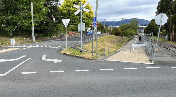
The ramp is substandard.
The mandatory crossing point is in a driveway and is adjacent to the speed hump.

And finally it’s not well lit at night.
How could it be improved?
It needs to be clear to drivers that a substantial number of pedestrians & cyclists cross here. They need to be persuaded to travel slowly and be given the best opportunity to see pedestrians & cyclists. Ideally the drivers would be required to give way to the more vulnerable road users.
Potential improvements include:
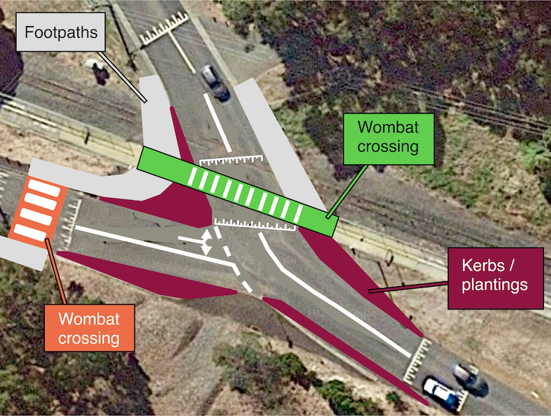
- Add a green raised wombat crossing across the Cycleway — gently ramped at each end. (The amount of elevation possible may be limited by the need to preserve the train tracks.)
- Get rid of the pedestrian island. Narrow the vehicle lanes. Widen the footpaths.
- Remove the left turn lane in Bellevue Parade entirely. Sharpen the angle of the turn to slow vehicles further.
- Turn the speed hump on Bellevue Parade into a wombat crossing. Extend the footpath to meet it.
- Shorten the rail fence, remove the roadside post and other obstructions.
- Improve the signage & lighting. Remove the redundant railway crossing signs which act purely as distractions.
How to get this done?
City of Hobart is responsible for the Queens Walk road crossing, as well as all the other road crossings on the Intercity Cycleway south of New Town Rivulet. Glenorchy City Council is responsible for the road crossings on the Cycleway’s northern end.
Hobart Streets submitted this idea to City of Hobart in November 2023 for consideration of inclusion into their 2024-25 budget.
How can I help?
Email the City of Hobart — coh@hobartcity.com.au — to let them know you think this is a great idea
Share this post with your friends & neighbours
Someone has done a huge amount of work in writing this post – bravo – I regularly ride through this crossing & have seen some poor motorist (& ICC user) behavior over the years. However, in the overall scheme of things, if we want to prioritize the most urgent safety issues around ICC road crossings, wouldn’t you consider Elwick Rd, Hopkins St, Derwent Park Rd, Sunderland St as needing more consideration? I have to giggle about the “Since it’s smooth” comment. With all the uneven edges between concrete pads, and the gutter crossings over Sunderland St, reverting back to the road north of Bilton St is far smoother, for me anyway.
Thanks Andrew! We chose this intersection as the example because lots of people commented about it on the BikeSpot survey and also so we could submit it to City of Hobart budget submissions open at the time (many of the other crossings are in Glenorchy). Definitely most of the other road crossings are equally or more in need of improvement.
“Smoothish” maybe?! Best bike infrastructure we have but yeah it’s not up to scratch for many reasons.
I agree with all the proposed changes. I cycle out of Queens Walk onto the ICC quite often. The intersection is a mess (from a navigation point of view) As a cyclist, I’m looking at cracks, train lines and broken bitumen edges to avoid (as well as the occasional bits of glass) and trying to guess what the traffic from 3 directions is going to do. Some cars give way (no requirement to do so) others charge through, still others hesitate, unsure what to do. Narrowing traffic lanes and making them quite precise in location, while making a clearly defined footpath and cycle path would be a great step forward.