A scenario for a medium capacity transport network for Hobart
By Seán Deany – Rail Futures Inc, Melbourne
As one who decided long ago not to own a car – making use of public transport – I soon became aware, as a resident of Hobart in 2000, of what was lacking in the Tasmanian capital. I then hatched the wild idea that perhaps a light rail metro system might be the answer for Hobart. This idea I put on the back burner for some time. About 10 years ago, I became a member of Melbourne’s Rail Futures Inc. – a non-partisan transport advocacy group / think tank made up of mostly retired engineers and transport nerds – like myself!
Light Rail – a once in a lifetime opportunity for Hobart
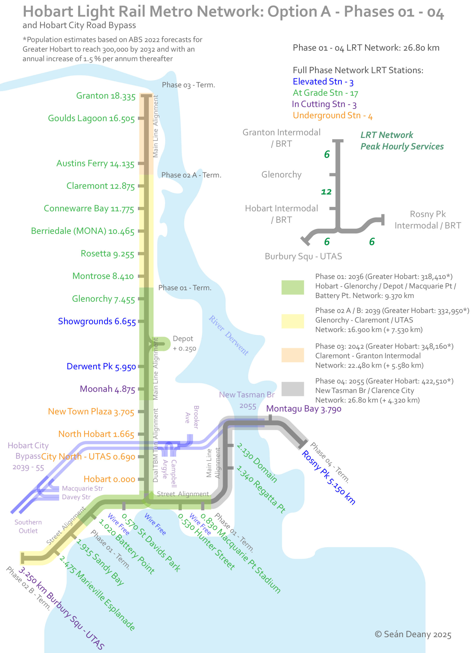
I have below presented an Option A scenario for the roll out of a multi-phased medium capacity transit system for Greater Hobart.
Options
I have investigated other options, for example the Riverline LRT (light rail transit), BRT – bus rapid transit and even trackless tram, all given in a number of recent Tasmanian Government studies. In respect to the information given and detailed analysis I have come to the conclusion that LRT is inevitably the long term solution towards mitigating road congestion, Hobart’s scourge of recent decades. Importantly an LRT network can also bring rapid connectivity of Hobart’s northern suburbs to the city core area, crucially acting as a once in a lifetime city-shaping endeavour with positive long term outcomes. This said, considerable planning and investment must be made.
Hobart Light Rail Metro
In my scenario for the so-called Hobart (LRM) Light Rail Metro network I envisage Greater Hobart becoming a denser and low carbon footprint city of 400,000+ by the year 2050. The Hobart and Glenorchy areas could potentially increase their populations with higher density housing, growing sustainably with the implementation of a core / network medium capacity transit system by the 2030s.

A light rail tunnel connecting Hobart to the northern suburbs
While costlier than BRT, and no doubt challenging in the first construction phase for this core / network, an underground tunnel (dual bored – 6.5m diameter TBM) of approx. 4.8 km in length and including its own suite of four underground LRT stations. The tunnel alignment, would be then followed by limited elevated structure in Derwent Park / Glenorchy – rail height above street level being approx. 7 m for level crossing removal.
The existing proposals
There are two Tasmanian Government LRT – light rail transit studies for Hobart’s northern suburbs from with which I will be comparing my scenario. These are the following: 2009 PB (Parsons Brinckerhoff – Hobart Light Rail Cost Estimate: Report 2) and the 2020 – 24 PwC (Pricewaterhouse Coopers Consulting) Northern Suburbs Transit Corridor – Transport Mode Study: Options Assessment Report.
2009 Parsons Brinckerhoff – Hobart Light Rail Desktop Study
While allowing for a cross city network, the light rail alignment was restricted to cross numerous street intersections and required a bidirectional alignment through the Elizabeth Street Mall. However, it did utilize the Main Line rail corridor as a dual track alignment to at least Claremont.
Numerous passing loops would be required along the remaining 9.2 km out to Bridgewater via Main Road Austins Ferry. On Main Road, Austin’s ferry, the gradients are steep, so therefore engineering guidelines would restrict its operation.
The PB 2009 study was made before the establishment of MONA, the construction of the new Bridgewater Bridge and any Macquarie Point redevelopment plans, therefore a little outdated now. However, it may have had potentiality by running along the Main Line corridor from Claremont, instead of along Main Road. Average operational speed was to be 31.5 km p/h. When taking into account it would have been as an entirely built-from-scratch transit corridor – the time taken from departure at Hobart City to Glenorchy is 19 min (although it was placed where the Showgrounds node is in my scenario and the PwC study. Therefore, would likely require a travel time from Hobart to Glenorchy of 20.33 min, Claremont 29 min and Granton 37 min.
2020 – 24 Pricewaterhouse Coopers – Northern Suburbs Transit Corridor

This is not necessarily an engineering requirement. For example, Sydney’s L1 – Inner West Light Rail navigates a 12 m corridor (including stations) and utilises a former freight corridor. Additionally, a ROW for street operations for LRT can safely navigate a 7.6 m wide corridor and width for transit stops between 11.1 m (elongated platform) to 12 m (island platform). Due to only a single track alignment, there are potential delays built in – systematically restricting punctuality. There is the need also for slower operational speeds when waiting for the other direction’s tram to pass, and multiple level crossings further add restrictions. Optimistically PwC has given an average operational speed of 31.75 km p/h. On the assumption that it will be an entirely built-from-scratch transit corridor, the time taken from departure at Hobart to Glenorchy is 20.14 min, Claremont 30.3 min, and Granton 41.51 min.
Hobart Light Rail Metro offers high operational speeds and passenger attraction to Hobart’s northern suburbs

The PB average operational speed is at 31.5 km p/h + 20 sec Dwell time applied at each stop along network. Oddly and possibly due to error they locate their Glenorchy Stn node approx. at the given Showgrounds node location in both other studies given here. I have therefore made an amendment to place it at the actual Glenorchy Central location for better comparison.
The PwC is for – LRT, BRT and Trackless Tram – and average operational speed is at 31.75 km p/h + 20 sec Dwell time applied at each stop along network. The LRT corridor is expected to follow the entirety of the Main Line rail corridor via Macquarie Point out to Granton.
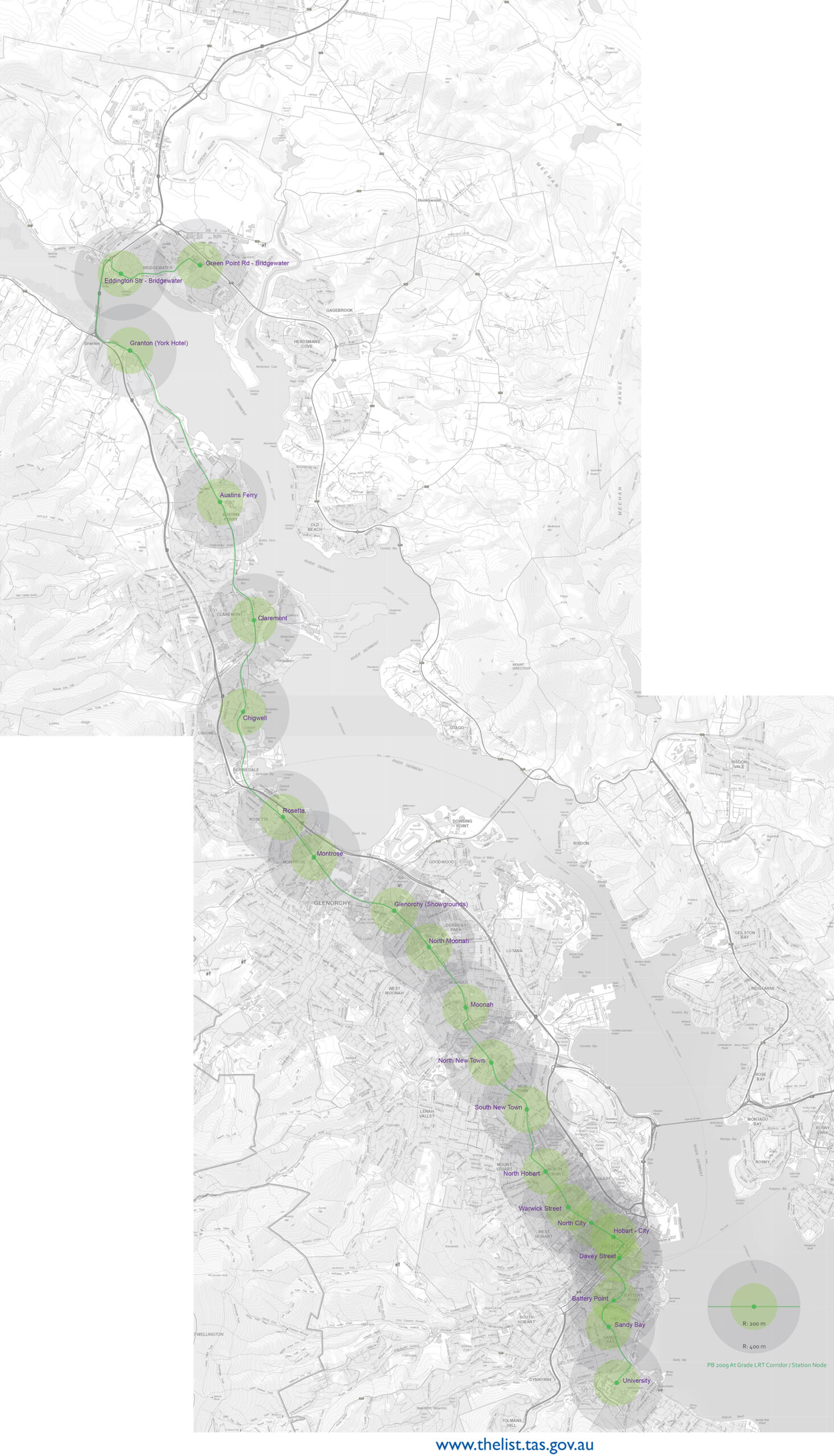
Hobart LRM distances and travel times between station nodes (*average operational speed from Hobart to Glenorchy is 55 km p/h + 20 sec Dwell times – along the fully grade separated LRT Tunnel / Cutting / Elevated alignment. From Glenorchy to Claremont it is at 35.6 km p/h, and Claremont to Granton is at 31.75 km p/h + 20 sec Dwell times). All my station nodes, with the exception of the Brooker Interchange, from Albert Road to Granton are in the same locations as those PwC / Aurecon have given, plus 3 additional ones at Montrose, Connewarre Bay and in Austins Ferry. My average operational speeds between all 15 given LRT nodes between Claremont and Macquarie Point via Hobart Tunnel were all calculated with the use of the following: Excel velocity-change-to-time-distance Calculator, Omni Speed Calculator, and all engineering guidelines used by Yarra Trams: Infrastructure – Tram Track and Tram Stop Design guidelines.
Hobart Light Rail Metro will operate a fully grade separated corridor to Glenorchy

My scenario eliminates the considerable amount of road level crossing conflicts en route to as far as Glenorchy, and maximises all amenity potentially available with the existing Main Line rail corridor – such as the Inter City Bicycle Route – and can free up additional public space. It would involve a 10 m wide elevated structure supported by 6.5 m single pillars to maximise space below, and to navigate the narrow sections of the Main Line corridor which can be as little as 13 m wide at its narrowest point.
Travel speed and time punctuality would be easier to meet via a seamless and direct medium capacity transit corridor from Hobart City directly to the northern suburbs via the established inner city areas of North Hobart and New Town, with an underground station node each. Considerable urban renewal and lower cost town housing – perhaps modelled on Melbourne’s Nightingale Housing for example – would likely be more viable in the New Town Plaza / Moonah / Derwent Park / Hobart Showgrounds / Glenorchy / Montrose precincts with a direct connection to the Hobart City / core area. The LRT Tunnel would be engineered for automatic train (LRT) control systems, be able to safely run LRVs at up to 85 km p/h, and have 2.5 min headways to allow for future growth demand for the network. The Hobart LRM network would be dual standard gauge track alignment to at least as far as Claremont and run LRVs – like Melbourne’s E class trams. Dual gauge track should be provided to run heritage narrow gauge rail from the Tasmanian Transport Museum in Glenorchy and out to Granton or assistance provided for a possible relocation to Bridgewater Junction.
Hobart Light Rail Metro would use wire-free operations in heritage areas of Hobart’s waterfront and Battery Point
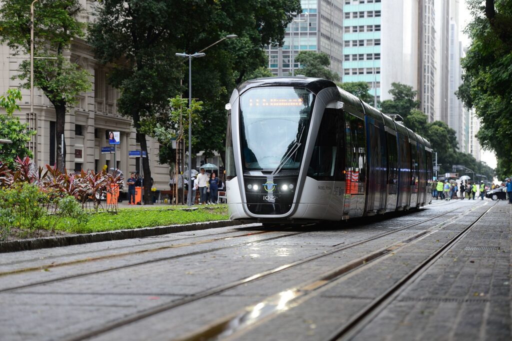
Moving south from the Hobart City station node, the line would resurface and bifurcate to wire-free corridors to both Macquarie Point and Battery Point in Phase One. Likewise, the former UTAS site and its extensive redevelopment would also offer high passenger attraction to LRT connectivity via Sandy Bay Road. In the longer term, there could be an Eastern Shore LRT connection to firstly Rosny Park via a new Tasman Bridge.
There would be a need for major road reconfiguration, particularly around the Macquarie / Davey Streets doublet. Tunnel portals would be immediately south of Macquarie Street to avoid conflicts there. Davey Street would require a 7.6 m wide dual LRT corridor with its own ROW and would require a 11.1 m wide corridor for elongated low-floor-height transit stops at both St Davids Park and Hunter Street. Therefore, the dual LRT corridor along Davey Street would need to occupy greater space than two road lanes currently in use, and would likely run along the outer or harbour side to reach Macquarie Point.
Primarily in my scenario is concerned with travel time and accessibility. The Hobart LRM can outperform by a long shot – when compared to the PB and PwC light rail studies, including bus rapid transit and trackless tram. This said, it is evident that the 2009 PB alignment does indeed perform better than the more recent PwC alignment for its ability to serve the inner city suburbs and offer equally city-shaping potentiality. BRT has its place in Hobart too where it can be rolled out in a shorter time period, and can allow for a swift and direct access to outer areas such as Bridgewater and Brighton, Kingston and Blackmans Bay.
However, when compared to an LRT network, it underperforms in providing what I consider to be a modern medium capacity transit system for a future vibrant Hobart. Trackless tram technology is largely underdeveloped and such tech-balns I believe are not the answer for Hobart. Their place is more related to BRT. LRT offers a more comfortable ride experience and a safer guideway through rail traction. Light rail infrastructure in many cases has what is called the Sparks Effect: It promotes a positive attraction to public transport by the general public.
My scenario for the Hobart LRM, sees the re-introduction of trams for Hobart as part of a modern and fully integrated transit system. It would act as a catalyst for change, paving the way for low carbon footprint city-shaping. Extensive transit-oriented development would help reduce road congestion, halt unnecessary urban sprawl into greenfield, and importantly allow for sustainable population increase within close proximity to Hobart’s activity centres. The identified and direct transit corridor given in my scenario would greatly improve connectivity to and from Hobart’s northern suburbs.
Hobart Light Rail Metro will encourage transit-oriented development in Hobart’s northern suburbs and a seamless connection between Hobart City and Glenorchy

Hobart Light Rail Metro allows for direct connectivity to the northern suburbs from the underground Hobart / nipaluna station – located beneath the Elizabeth Street City Bus mall.

Hobart Light Rail Metro will be provisioned with a 4.8 km TBM tunnel from Hobart to the northern suburbs with its own suite of 4 underground stations


Hobart Light Rail Metro might take shape from the mid-2030s
Recent developments in Light Rail in Australia and abroad
I have not made any comprehensive and realistic cost estimate as yet for my scenario for the Hobart LRM. However, the logical way to formulate some cost estimates for the Hobart LRM network is to first look into details regarding other Light Rail networks in Australia and abroad. Fortunately, these are all relatively recent developments and present some similarities to the scenario I have worked on regarding Hobart. The high cost for its initial construction phase would depend on Federal Government funding and the possibility of a congestion tax, particularly in regards the Macquarie / Davey Streets doublet. Value capture arising from the new developments around station nodes can be effected.
01: Canberra Metro. Australia
Stage 1: Civic – Gungahlin 12 km / 14 stops. In operation since April 2019
At-grade / 14 low floor stops / Standard gauge / 14 x LRVs – 33m / Depot – Stabling and Operations / 750V DC Overhead
Stage 1 – AU$675 million (AU$56.25 million per km)
Stage 2A: Civic – Commonwealth Park 1.7 km / 3 stops. In operation later in 2025
At-grade / 3 low floor stops / Wire Free / Major road reconfigurations
Stage 2A – AU$265 million (AU$155.88 million per km)
Stage 2B: Commonwealth Park – Woden via State Circle East 9.7 km / 9 stops. In advanced planning phase
At-grade / 9 low floor stops / New bridge structure crossing Lake Burley Griffin via Commonwealth Ave
02: Gold Coast G Link. Australia
Stage 1: Parklands – Broadbeach 13 km / 16 stops. In operation since July 2014
At-grade / 16 low floor stops – 1 Underground / Standard gauge / 14 x Bombardier Flexity 2 – 43.5m LRVs / Depot – Stabling and Operations / 750V DC Overhead
Stage 1 – AU$1.6 billion (AU$123 million per km)
Stage 2: Parklands – Helensvale 7.3 km / 3 stops. In operation 2025
At-grade / 3 low floor stops / 4 x Bombardier Flexity 2 – 43.5m LRVs / Connection to Queensland Commuter Rail Network at Helensvale Stn
Stage 3: Broadbeach – Burleigh Heads 6.7 km / 8 stops
At-grade / 8 low floor stops Stage 3 – AU$1.2 billion (AU$179.10 million per km)
Stage 4: Burleigh Heads – Coolangatta 13 km / 14 stops. In planning phase
At-grade / 14 low floor stops / Connection to Gold Coast International Airport
03: Granada Metro. Spain
Stage 1: Albolote – Armilla 15.92 km / 26 stops. In operation since September 2017
At-grade – 83% / Underground 17% (2.72km) / 26 low floor stops – 3 Underground stations / 15 x Urbos III LRVs 32.33m / Depot – Stabling and Operations / 750V DC Overhead / Wire-free 4.69 km – 4 segments / Granada Metro, with 11 million users registered in 2022, prevented the emission of more than six thousand tons of CO2 into the atmosphere that year.
Stage 1 – 558 million euro (AU$1.007 billion at 2022 / AU$63.25 million per km)
Stage 2: Extension of existing line and inner city Loop creating 3 Lines in total
04: Newcastle Light Rail. Australia
Stage 1: Newcastle Interchange – Newcastle Beach 2.7 km / 6 stops. In operation since 17 February 2019
At-grade / Standard gauge / Wire-free / 6 x CAF Urbos 100 LRVs 33m super capacitor trams / Temporary Wickham Depot – Stabling and Operations.
Stage 1 – AU$560 million (AU$207.40 million per km)
Stage 2: Newcastle Interchange – John Hunter Hospital 6.65 km / 7 stops. In preliminary planning phase
At-grade / 750V DC Overhead / 6 x CAF Urbos 100 LRVs 33m super capacitor trams
05: Ottawa O-Train. Canada
Stage 1: Confederation Line 12.5 km / 13 stations. Operations commenced on 14 September 2019
Fully grade separated with 2.5km Downtown tunnel / 13 stations – 4 underground / 17 x coupled Alstom Citadis Spirit LRVs / Depot – Stabling and Operations / 1500V DC Overhead / Capacity for 10,700 passengers per hour
Stage 1 – CA$2.1 billion (AU$2.292 billion – AU$183 million per km)
Stage 2: Confederation Line extension 27 km / 16 stations. Currently under construction and through operations due in 2026
Confederation Line West: 15 km / 11 stations / Confederation Line East: 12 km / 5 stations / Additional Depot – Stabling and Operations
Stage 2 – CA$4.66 billion (AU$5.84 billion – AU$216 million per km)
06: Parramatta Light Rail. Australia
Stage 1: Westmead – Parramatta – Carlingford 12 km / 16 stops. In operation from 2025
At-grade / 16 low floor stops / Standard gauge / 13 x CAF Urbos 3s LRVs – 45m / Depot – Stabling and Operations / 750V DC Overhead / 2 Wire-Free sections: Westmead Hospital – Ngara 1.7km and Prince Alfred Square – Tramway Ave 2.3km / Conversion of the existing Carlingford heavy rail corridor to light rail operation, including a parallel 8.5km active-transport corridor / Estimated to transport 28,000 people daily
Stage 1 – AU$2.875 billion (AU$239 million per km)
Stage 2: Parramatta CBD to Sydney Olympic Park 10 km / 14 stops
14 low floor stops / Connects to three transport interchanges on the Stage 1 alignment; the future Sydney Metro West and heavy rail in Parramatta and Sydney Olympic Park / Connects with ferry services at Rydalmere and Sydney Olympic Park
Stage 2 – AU$602.4 million (AU$60.24 million per km) In final planning phase before construction commences
Acknowledgements
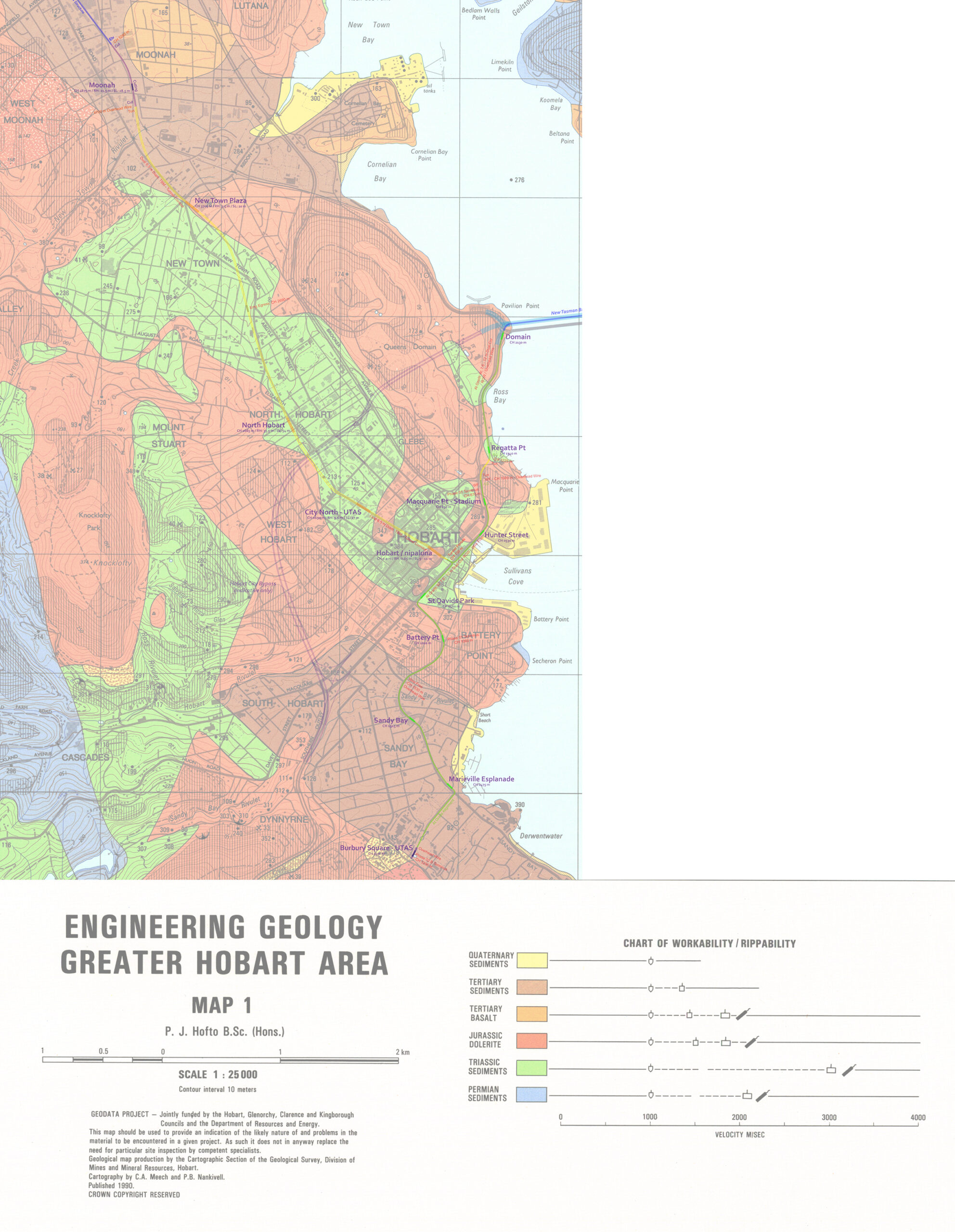
I would like to acknowledge City of Hobart – Planning for providing detailed city mapping and my colleagues in Rail Futures Inc. for their interest.
Amazing report Sean but I just can’t see where the money could ever come from. The 2020 PwC report in table 20 had stage 1 capital costs of LRT:$454M BRT:$338M TT:$388M. The state is already massively in debt with the Bridgewater Bridge, Tasman Hwy thru Midway Pt, Mornington r’bout, and now possible AFL stadium. At say $200M/km (based on other projects) your vision would be heaps more again. We’re not in a marginal electorate & I don’t see why the federal govt. would be keen. Car parking at stations? Where is the land? At least with BRT, the buses can feed in/ out of stations & on to ordinary roads, so less private parking is needed. As far as I know, the state govt & HCC are 100% committed to BRT.
Cost to build isn’t the only consideration though. Bus rapid transit running costs are higher due to the smaller vehicles needing more drivers. And Metro’s “temporary service reduction” of 180 services for almost 2 years now is due to their ongoing driver shortages. Good argument to splurge and go full driverless light rail!
The high cost to deliver phase one for the Hobart Light Rail Metro will be difficult to convince the public and state government. It is comparable to building and major stadium and arterial road bridge all at once plus added extras. Delivery of a core network medium capacity transport system for Hobart will be a game changer and potentially benefit the Tasmanian economy in the longer term
Buses won’t bring the housing density that other models will.
The northern suburbs actually has a land use problem, not a movement problem. Hence the extra money for LR as stated in your comment makes way more sense to stimulate more housing than buses ever will. Have a look around Australia, no other city is building housing precincts around busways.
See NSW TOD program
https://www.planning.nsw.gov.au/policy-and-legislation/housing/transport-oriented-development-program/transport-oriented-development
Or Melbourne https://www.abc.net.au/news/2024-10-20/victorian-government-high-density-activity-centres-melbourne/104494852
Or Brisbane
https://www.theguardian.com/australia-news/article/2024/may/16/brisbane-city-council-parking-requirements-developers-housing-costs
Don’t get sucked into the bus love, it literally makes no sense for the corridor and will be a complete lost opportunity for housing
Indeed LRT is a definitive catalyst for stimulating transit oriented development close to the numerous station nodes. It’s considerably higher cost is well worth the investment as it will bring well placed and possibly lower cost housing.
No direct replies to my questions. And how does it extend the service across to Bridgewater/ Brighton or the eastern shore say outwards from the Tasman Bridge? $2B for 10km? It ain’t gunna happen. Also comparing Hobart with 300K population to other major cities with 10x the # people & population density?
No direct replies to my questions. And how does it extend the service across to Bridgewater/ Brighton or the eastern shore say outwards from the Tasman Bridge? $2B for 10km? It ain’t gunna happen. Also comparing Hobart with 300K population to other major cities with 10x the # people & population density?
In conclusion to my given scenario above for the Hobart LRM I have included the proposed Macquarie Point Stadium – however I don’t support its construction at this site and at this particular point in time. I had merely included it as a best case scenario with integration with a medium capacity transit system – ie: Hobart Light Rail Metro. This said I wholly support a Tasmanian AFL / AFLW team – which can only bring great benefit to the Tasmanian economy and more importantly social moral to the island state.
Therefore when concerning the given Macquarie Point Stadium site chosen I do not support it for the reasons given below:
The Hobart CBD and inner city area has many restrictions due to mostly geography. I strongly believe that the proposed Macquarie Point Stadium – while of state of the art design and functionality does fit the given location.
The Mac Point Stadium structure and associated concourse is to occupy approx. 4.94 hectares (or 49,400 square meters) of the 10.27 ha Macquarie Point Precinct. Gruen Land Values estimate for Hobart CBD for 2030 are at approx. AU$828 per square meter and may return $41 million in sales to the Government owned land. Additionally limited mixed use development (0.82 ha) and land sold to the federal government for the Antarctic Facilities Zone (0.64 ha) may additionally bring in a further $12 million. This totals at approx. $53 million in revenue for the state government. However the total cost of the proposed Mac Point Stadium – for its 10 years development phase may amount to as high as $1.8 billion of which I understand the Tasmanian state will have to pay for. The precinct is likely to only host 25 – 50 events per year after completion. Most of the time during the course of the year it would remain idle.
In the original proposal for the use and redevelopment for Macquarie Point there were to be 3.69 ha of land for mixed use development with the addition of 0.66 ha for residential at Regatta Point. Potentially this would have meant possible thousands of homes in close proximity to Hobart’s CBD. It would have still utilized the Goodshed and Public open space would be at 2.75 ha – actually greater than the Aboriginal Culturally Informed Zone 1.45 ha. So with the proposal to build the Macquarie Point Stadium there is a lost opportunity to redevelop the land for better urban renewal.
Lastly the $1.8 billion required for the stadium zone in its entirety could better be spent on a given medium capacity transit system for Hobart.
I agree with many of the ideas listed, however as we’ve seen with both Melbourne and the Gold coast Metro, having expanding out loops like with the Moscow rail system is the most efficient and effective way to both reduce congestion on the lines by trains and passengers, while also cutting travel time by a wide margin. Having an offshoot circuit from Glenorchy, or at least the expandable option of one that uses the Bowen bridge and goes to Risdon Vale down to Rosny park will reduce congestion on the main line, having and expansion of that go up to Bridgewater also having a further circuit through Otago and old beach up to Bridgewater would further reduce future congestion issues.
There should also be lines that go out to Sorell and Kingston.
This will allow those who live on the absolute outskirts like those who live in Dodge’s ferry and Richmond to have greater access to public transport. This also allows the ability for commute to those who would wish to work at the various and many vineyards and distilleries that exist in the north east. While also allowing for a LRM line to run through the Hobart Airport, and Allow both easier access and shorter travels time for both tourists and also locals without access to Motor Vehicles.
The Kingston Line would allow for access to both the Taroona and Blackman’s bay suburbs, while also shortening commute times and allow access via public transit from both Margate, Snug, Huonville and Cygnet. Preventing further migration of young people from those areas.
Funding is a rather easy thing to acquire if you consider the options available to our state government. Create a Tax credit scheme for solar panels wherein every dollar spent gives a certain amount of tax credits to those who spend it. Focus on large companies like Coles, Woolworths, the Aluminum processing plant, those with warehousing space in the Derwent parks area, then replace and upgrade the electrical grid to handle the throughput.
This stops our required imports of Fossil fuels while also lowering electricity costs for residents and providing power for green public transit like the LRM and BRT systems. This also simultaneously helps meet the Green Energy Targets set by the federal government, helps meet the needs of the A.I. Data center they’re putting in (WTF) while also increasing the attractiveness of those in manufacturing industries to create plants and factories down here with the reduced electricity costs. Creating more high and middle income jobs.
Easy, Efficient, Helps grow local business, provides further population growth via Immigration, stops the brain drain, provides more funding availability via GDP growth for educational and healthcare investments and improves the entire city in infinitesimally small yet countless ways.