The Tasmanian State Government is planning a new stadium in Hobart. How will the crowd get to and from Macquarie Point?
Here we look at the transport-specific details in the planning documents submitted to the Tasmanian Planning Commission to see what it could be like getting to and from a new Hobart stadium at Macquarie Point.
How will people get to the new Hobart stadium?
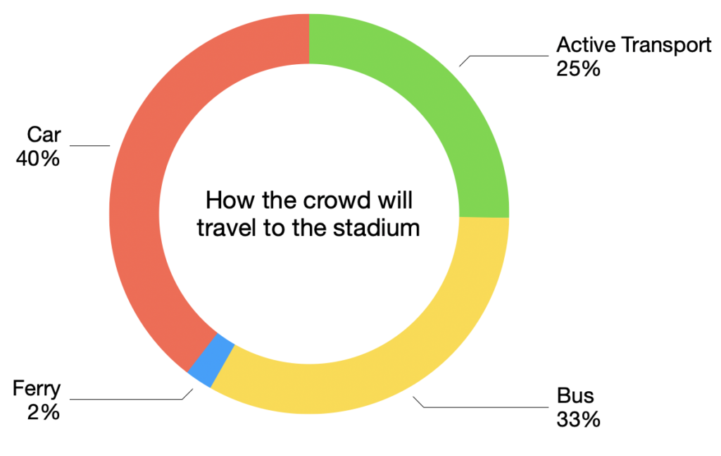
The maximum crowd at the stadium will be 31,500 — during a concert with 24,500 in seats and 7,000 standing on the field. With a stated target of 40% travelling by car, modelling suggests the following numbers of people using each mode of transport:
| Walk | Bike* | Bus* | Rapid bus | Event bus | Ferry | Car* | Taxi* |
|---|---|---|---|---|---|---|---|
| 6,900 | 1,100 | 1,100 | 1,000 | 8,300 | 700 | 9,300 | 3,200 |
* Bike includes scooter and other micromobility. Bus includes Metro, Tassielink & Kinetic services.
Car includes other private vehicles. Taxi includes ride share like Uber.
Active transport
Predictions suggest about 22% of the crowd will walk to the new Hobart stadium. Walking will also be the final part of the journey for many others. A further 3% of the crowd is predicted to arrive by bike, scooter or other micromobility device.
Infrastructure improvements
To facilitate active transport, the plan is to build:
- A new active transport bridge from the end of Collins Street across both the Brooker & Tasman Highways.
- More bike paths including along the length of Collins Street, along the waterfront and around the stadium itself.
- Three permanent bike & scooter parking areas.
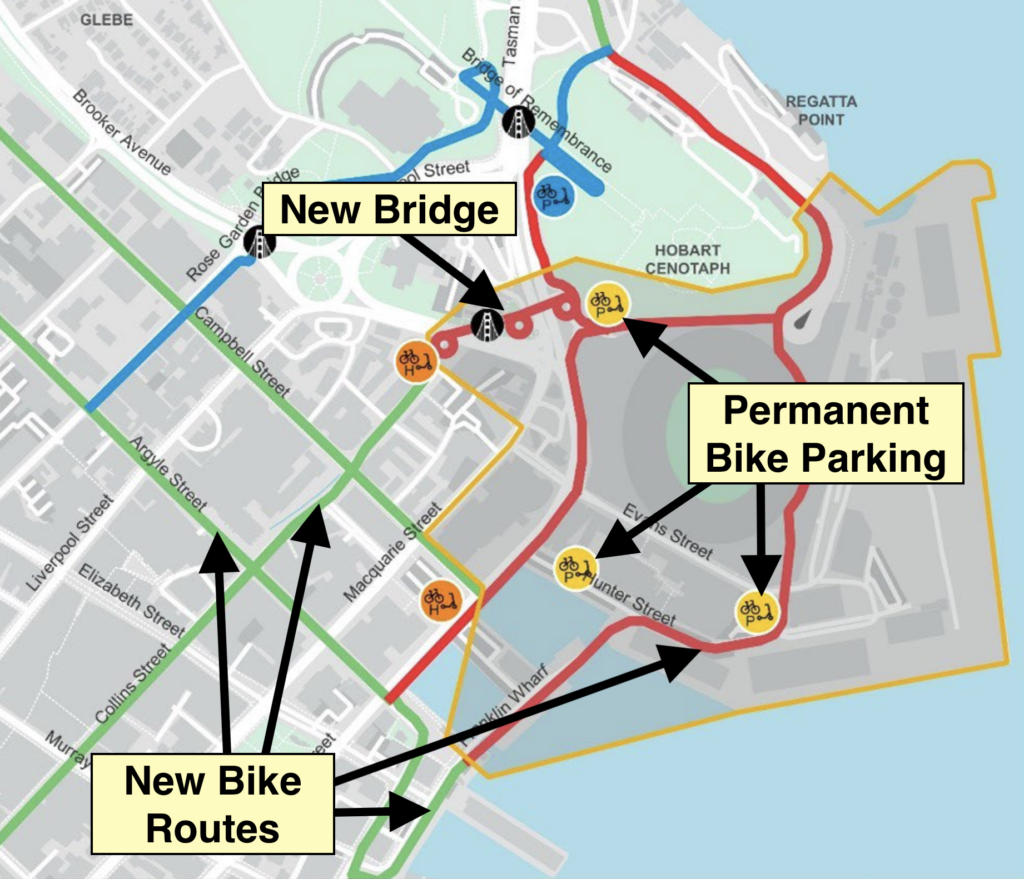
There will also be upgrades to footpaths, including on streets like Davey, Hunter, Evans & Collins.
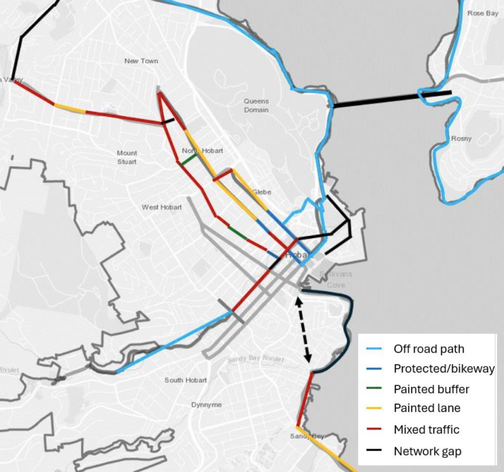
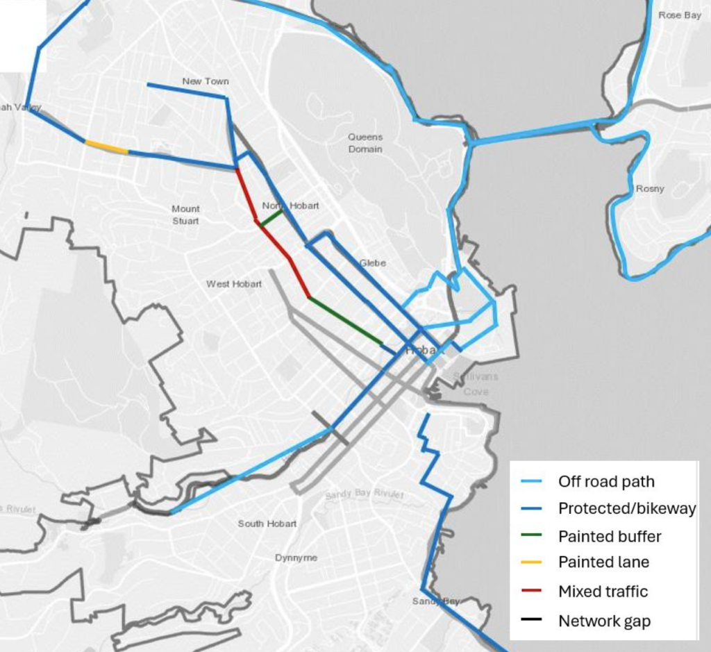
The wider bike network will progress significantly towards the vision in the Greater Hobart Cycling Plan as shown by these before & after maps:
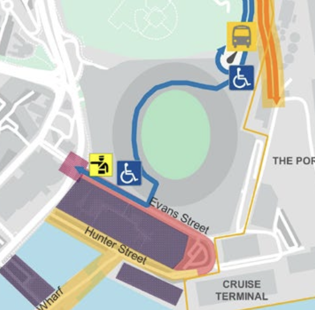
Event day changes
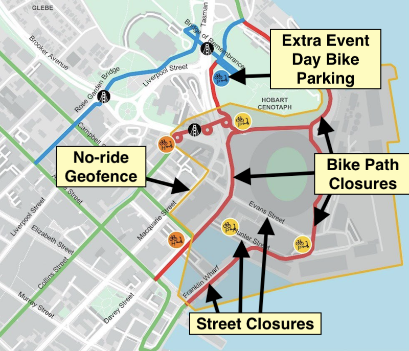
There will be effects on active transport around the stadium on event days:
- Evans Street, Hunter Street & the waterfront closed to traffic, allowing people to walk safely near the stadium. Opening of the Victoria Dock Bridge may also be restricted.
- Multiple bike paths near the stadium will be restricted when lots of people are moving in or out of the stadium. People on bikes will need to either dismount or ride via the Rose Garden Bridge.
- A no-ride geofence around the stadium for shared mobility devices (currently Beam e-scooters).
- Temporary secure bike & scooter parking near the end of the Bridge of Remembrance.
Bus
One in three stadium attendees will take a bus. Their options:
- Existing bus network — as operated by Metro, Tassielink & Kinetic.
- Rapid bus network — a new bus network currently in the early stages of planning.
- Event buses — extra buses running on event days.
- Private charter coaches (an example might be a Tassie Devils supporter bus from Launceston) — drop off & pick up either at the Domain and people walk, or at a Park & Ride and people transfer to an event bus.
Rapid bus network
Bus rapid transit for Hobart has been in the works for a while but details remain relatively scarce. The key points are:
- Frequent large buses.
- Dedicated lanes separated from general traffic.
- Stops more like railway stations than bus stops.
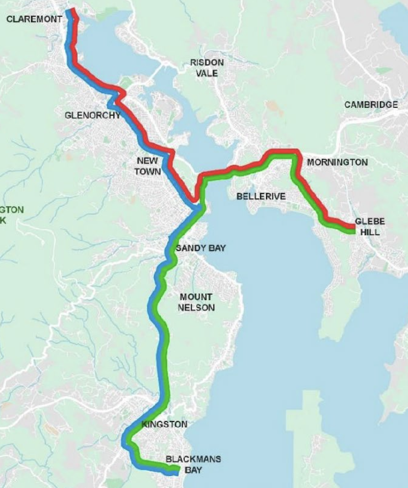
- Three routes to the north, east and south →
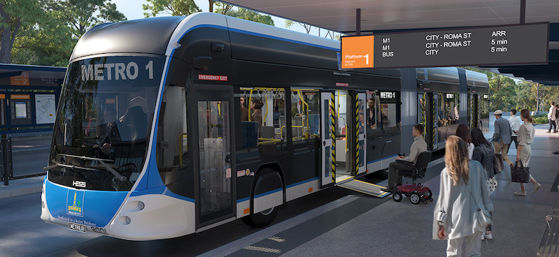
For an example of how bus rapid transit can look, check out at the imminent Brisbane Metro.
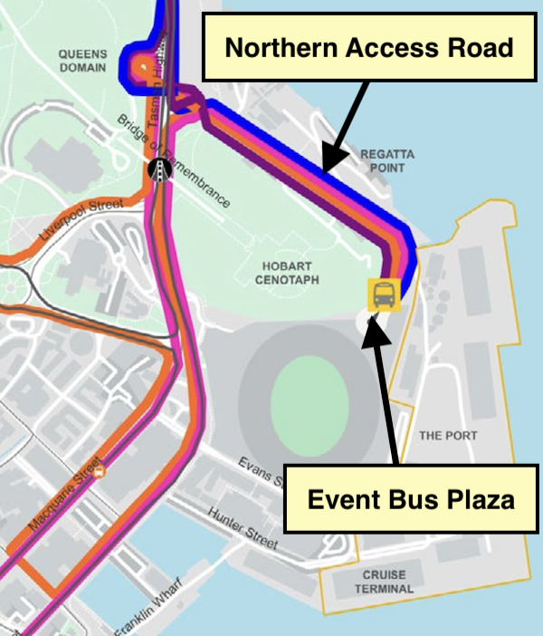
Event buses
Event buses will:
- Carry over 25% of the crowd to and from the stadium.
- Travel largely along the rapid bus network routes.
- Connect to Park & Rides — existing (eg Huntingfield), planned (eg Rokeby & Claremont) and ad-hoc (eg Wilkinsons Point & Geilston Bay).
- Drop off and collect people in the Event Bus Plaza just north of the stadium →
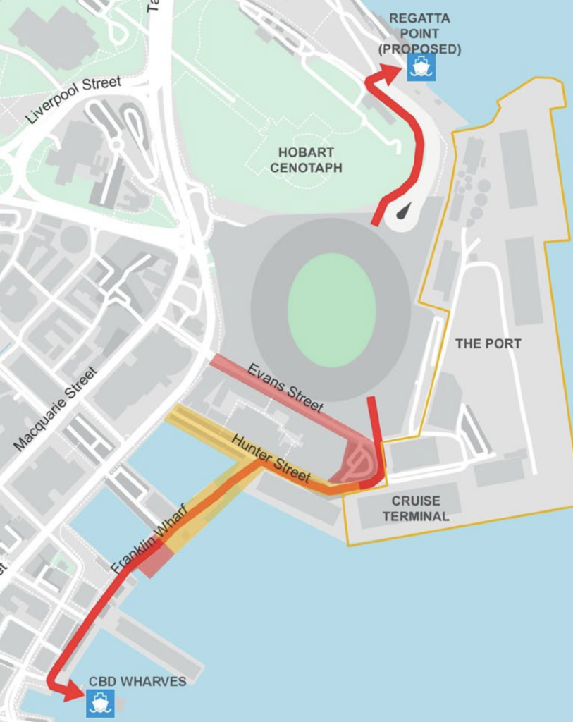
Ferry
Ferries in Hobart currently travel between the CBD and Bellerive.
Under the ferry masterplan, wharves will be built at Lindisfarne, Sandy Bay and Wilkinsons Point between 2026 and 2028. This means stadium patrons will be able to walk along the waterfront on closed roads to the CBD wharf to catch ferries to four destinations.
There’s also a wharf planned for Regatta Point north of the stadium. However this is as yet unfunded and it’s not yet clear when it will be built.
The prediction is 2% of the stadium crowd will travel by ferry.
Car & taxi
Trip times
If the target of 60% travelling by active & public transport is met, the modelling suggests the following car trip times to an evening event with capacity concert crowd of 31,500:
- Tasman Highway from Rosny Hill Road — 8 minutes (vs 11 min in morning peak).
- Southern Outlet from Olinda Grove — 10 minutes (vs 14 min in morning peak).
- Brooker Highway from Elwick Road — 12 minutes (vs 15 min in morning peak).
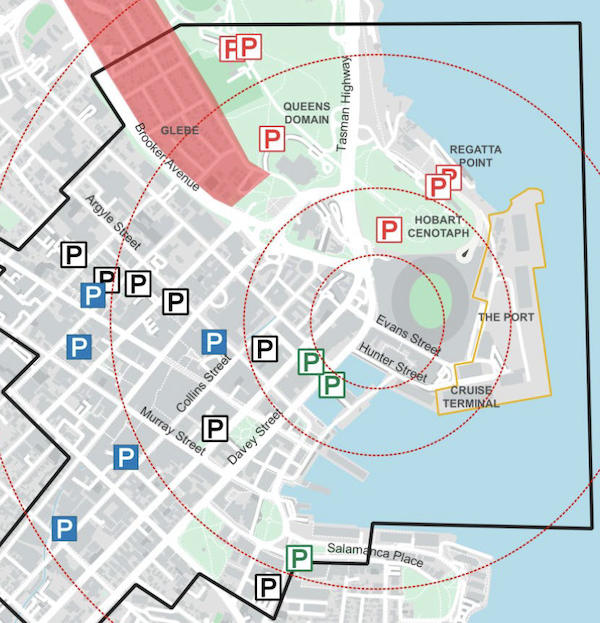
Parking
The assessment found there is ample existing facilities in and around the CBD to accomodate the intended share of the crowd that will arrive by private vehicle and taxi / ride share.
- There won’t be a public car park at the stadium.
- There probably won’t be any new ranks for taxi & ride share.
- There won’t be a drop off / pick up area for general use — only for people with disabilities.
- The cenotaph grounds and much of the Domain is not recommended for event parking.
Our thoughts
The good
- The focus is on facilitating multiple modes of active and public transport: walking, riding, buses and ferries. There is a clear acknowledgment that private vehicles can’t be how most people get to the stadium.
- A rapid bus network is essential to the stadium transport plan and its development will need to be expedited — better public transport in Hobart sooner.
- Connecting the existing fragments of bike network and improving it to all ages and abilities standard is similarly incentivised.
- The stadium will also bring focus to having high quality footpaths and pedestrian crossings in the area around the stadium (waterfront we’re looking at you).
- Making the length of Collins Street an active transport spine following the path of the rivulet through the city is good place making and will improve the CBD.
- Evening and weekend stadium events would hopefully be a catalyst for public transport providers in Hobart to start providing a more acceptable level of service outside of peak commuting times.
- By blocking the connection to the CBD, the stadium prevents the north-south rail corridor between New Town and the Cenotaph being used for light rail or bus rapid transit. This seems like a negative and some will reasonably consider it as such. However a route through the far more populated North Hobart is the better choice. This section of rail corridor is then freed up for other purposes. For example separate pedestrian & cycle paths instead of the existing shared path, a linear park or perhaps a tourist tram.
The less good
- Few of the public and active transport projects have progressed beyond the conception phase. This is in stark contrast to the new Hobart stadium itself which has overt government support, well-progressed planning and committed funding.
- Some of the numbers just don’t seem right. Only 1,000 bikes and scooters? And 1,000 on rapid buses — that’s less than 6 full Brisbane Metro sized buses.
- The limitations of ferries are revealed — only 2% of people are predicted to arrive by ferry. Though again the numbers here feel off — just 350 passengers at each of the two ferry terminals. A moderate sized ferry — the Mona ferries for example — carry about 200 passengers. Cricket matches at Bellerive Oval fill multiple ferries — that’s with a smaller crowd, longer walk and only one destination.
Where’s the new Hobart stadium at?
The stadium itself still needs to get through both the planning commission and state parliament before its approved and construction can start. If approved it’s due to be completed by 2029.
The active & public transport infrastructure needs to be built regardless of whether the stadium goes ahead — and the sooner the better. Hopefully City of Hobart and the Department of State Growth just crack on.
More info
Tasmanian Planning Commission, Stadium Assessment page — includes the government’s submitted reports — chapter 4 in the Summary Report & Appendix N deal with transport.
I am fully supportive of a new stadium in Hobart. The proposal here has enormous
potential to regenerate a city that keeps fumbling around with concepts without developing. Ideologists have plenty of other places to go and smell the grass, take their crapping dogs or gaze longingly at the moving clouds above. The HCC should get their heritage trams out of storage and create a special line around Sullivans Cove to interlink the stadium precinct with Salamanca place.