The state government is adding new traffic lights and pedestrian crossings to the Brooker Highway intersection at the Montrose foreshore.
The existing intersection
The Foreshore Road / Duncan Street intersection is the first intersection after MyState Arena heading north along the Brooker Highway.

Foreshore Road gives access to:
- Montrose Bay High School.
- The shared use path along the foreshore — a very popular place for walking, running and riding. It hosts a parkrun on Saturdays.
- A playground, skatepark, BBQs, boat ramp, yacht club and rowing club.
Duncan Street connects to the residential suburbs of Montrose and Rosetta.
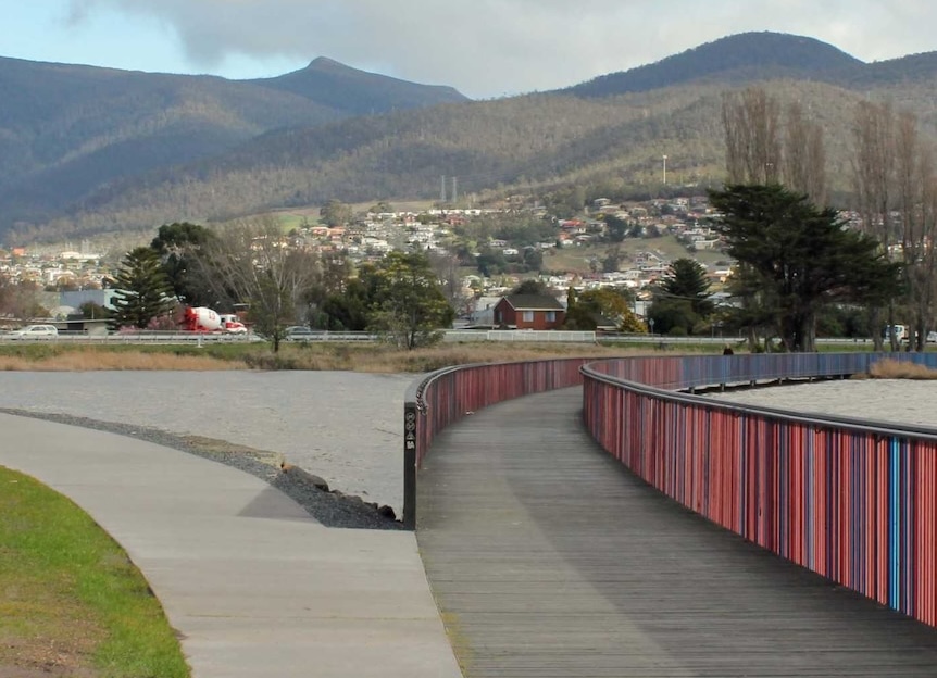
This section of the Brooker is divided highway with two lanes in each direction and a speed limit of 80 km/h. There’s no traffic lights so people driving out of Foreshore Road or Duncan Street need to give way to up to four lanes of Brooker Highway traffic.
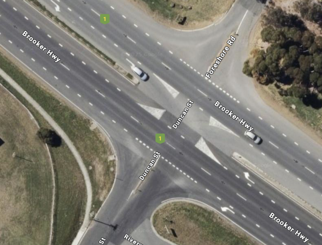
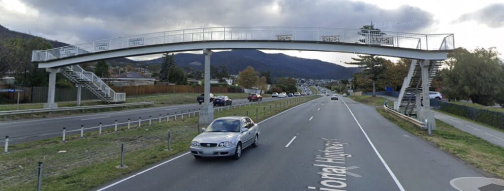
There’s no footpaths or pedestrian crossings at the intersection and it’s not intended that people cross the highway here (though they do). Instead there’s a pedestrian overpass north near the high school. It’s 200 m from the Duncan Street intersection (and a similar distance from the Dodson Street intersection in the other direction) so using it potentially adds 400 m of walking next to the highway to your trip. The overpass has steep stairs and therefore can’t be used by people with prams, in wheelchairs, on scooters or riding bikes.
There’s no infrastructure at the intersection to support people riding bikes.
What’s the plan?
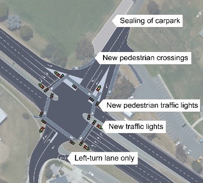
The state government is planning to add traffic lights and pedestrian crossings to the intersection.
Our thoughts
The good
- The existing intersection is a poor design and unsafe for all road users with a high risk of collisions at high speeds. Of note, a pedestrian hit by a car at 80 km/h has an essentially 100% chance of dying. The proposed changes will improve safety for people whether they’re driving, riding or walking.
- This is a key intersection because it connects residents from Montrose and beyond with important educational, recreational and active transport facilities. Making the intersection easier to navigate will strengthen this connection.
- A safer intersection here will encourage people to use active transport rather than drive and will therefore reduce traffic, particularly during the peak school times.
- Allowing young people to safely walk and ride to school is especially important since 83% of Australians aged 15–17 are insufficiently physically active (AIHW). Active travel is one of the easiest ways to incorporate physical activity into everyday life.
The less good
Choice of intersection type
The intersection will remain “at grade”, meaning there’s no overpass or underpass component.
- Instead traffic lights will be used to divide time between people travelling through the intersection in different ways. Crash avoidance will be entirely reliant on people obeying the traffic lights — which they don’t always do — and so this solution will be less safe than one that physically separates people.
- Traffic lights also mean delays. The width of the intersection (6 lanes!) and the pressure to keep traffic moving on the Brooker could well mean pedestrians are not able to complete the crossing in one phase. It’s stated that the traffic lights will be synced with other intersections along the Brooker to ensure efficient traffic flow, however the change in travel times isn’t quantified.
- The project page states “initial investigations found it is not feasible to install an overpass or roundabout” but doesn’t explain why. Cost is presumably a major factor.
Intersection design
Even accepting that traffic lights are the chosen solution, there are many design features shown in the draft design which reduce the safety of the intersection for vulnerable road users.
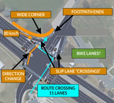
- There are two slip lanes to allow vehicles to turn left into and out of Foreshore Road by giving way rather than being controlled by traffic lights. While this reduces delays for traffic, slip lanes are notoriously dangerous because people driving are looking right for traffic to give way to and fail to see pedestrians. The slip lane turning off the Brooker is of particular concern since vehicles need to slow from 80 km/h and the large corner radius will encourage maintaining high speed through the turn.
- Neither slip lane has traffic lights, a wombat crossing or a pedestrian crossing. This implies pedestrians will be required to give way to vehicles here which is inappropriate.
- There’s no infrastructure to support people riding their bikes. This is despite the fact the intersection is an obvious way for people to ride to the Montrose Bay shared path and for high school kids to ride to school. It’s been marked as a secondary route on the draft Glenorchy Cycling Infrastructure Plan. Of note the Montrose Bay shared path is a designated route on the Greater Hobart Cycling Plan and is a state government responsibility.
- Pedestrian crossings change directions through the medians. This undesirable per Austroads standards because it makes it harder for people with impaired vision to navigate.
- The footpaths appear to end in a carpark.
- Pedestrians cross lots of lanes.
The take home
The Montrose foreshore intersection is an important intersection which is currently very unsafe. The proposed upgrade will improve safety to a degree but will fall far short of an appropriately safe modern intersection.
Where’s it at?
Construction starts on 11 August 2025.
Weather permitting, the changes will be complete in April 2026.
Previously…
- Concept design finalised in 2022 with “resoundingly positive” feedback from consultation with “directly impacted stakeholders”.
- Detailed design finalised and funding confirmed in December 2024.
- Project details with an illustrative design made public 23 December 2024.
More info
- Tasmanian Department of State Growth — Montrose Foreshore Intersection Upgrade project page
- Email montroseforeshore@stategrowth.tas.gov.au