UPDATED to the endorsed design
as at 31 March 2025
Much more than bike lanes — here’s a deep dive into the changes coming to three blocks of Collins Street in Hobart’s CBD in 2025.
What’s the plan?
City of Hobart has released the final design showing changes planned for the three blocks of Collins Street between Molle & Murray Streets.
The changes include:
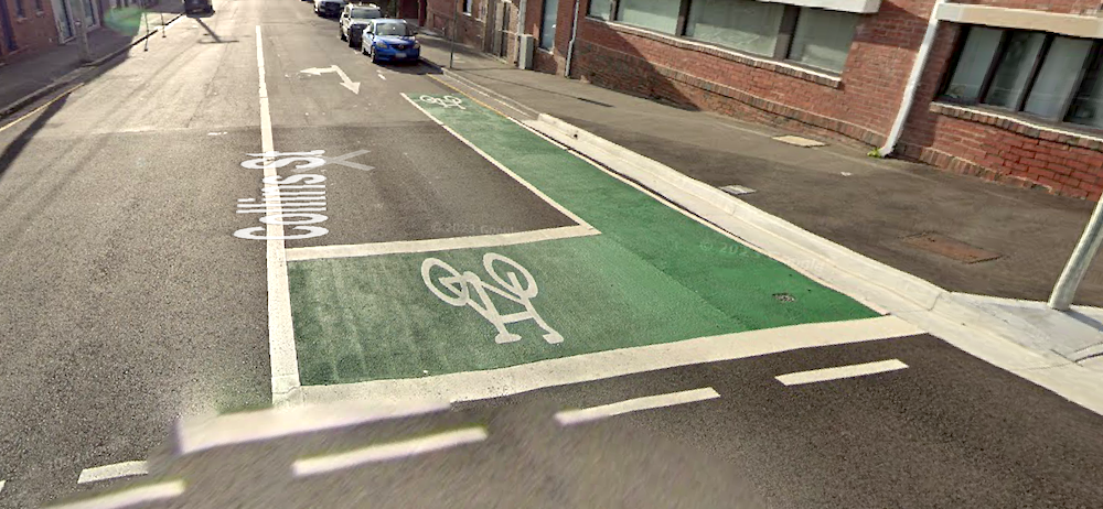
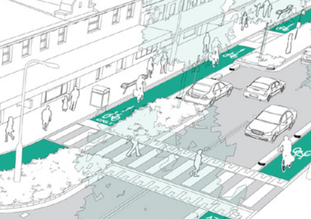
- Kerbside protected bike lanes — one in each direction for much of the three blocks.
- Speed limit change from 50 or 40 km/h to 30 km/h.
- On street car parking changes — some spaces removed. All loading zones retained. Two disability car parks retained with additional disability parks to be installed nearby.
Twoone parklet for on street dining.- New pedestrian zebra crossings at the Victoria Street intersection. →
- Consolidation of two bus stops into a so-called “superstop”.
- Opportunities for urban greening and bike & scooter parking.
Molle–Barrack–Harrington
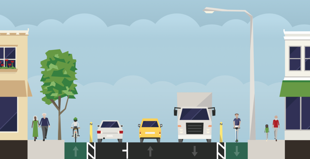
For the two blocks between Molle and Harrington Street, the existing traffic lanes are wider than required. By narrowing these lanes it means that two protected bike lanes will be added while retaining one parking lane for the majority of the two blocks.


Harrington–Murray
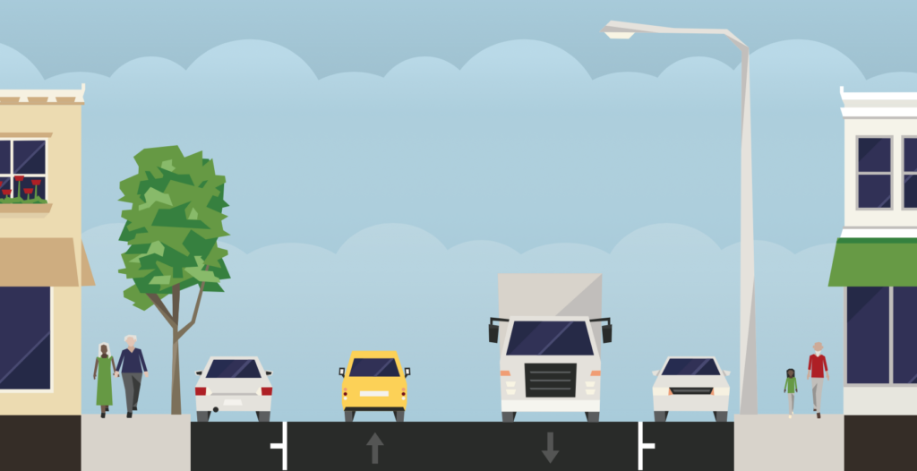
The plan is a bit different between Harrington & Murray Streets. Less available space has meant that adding two protected bike lanes would require removing two of the four car lanes. The planners have elected to retain two driving lanes and remove some parking.
The originally endorsed design had a protected bike lane in each direction between Victoria and Murray Streets, as well as two parklets for on street dining near Harrington Street.

At some point the smaller area for on street dining on the eastern side of the road has been removed from the plan.
More significantly, the council endorsed a new design for the Victoria to Murray Street section at their March meeting. This design removes the southbound protected bike lane and instead retains the current parking. Bikes travelling south will need to share the lane with traffic for the length of the block.


Tactical?
This is a tactical project because the council will implement the changes using temporary measures like paint & bollards rather than more permanent adjustments such as altering kerbs. This means it’s quick to install and can be easily modified in response to ongoing assessment.
The plan is for a 24 month trial period. During that period there will be monitoring of a number of metrics — number of people on bikes & scooters, number of pedestrians crossing mid block (as a surrogate for perceived safety), parking occupancy, vehicle speeds, traffic impacts, confidence of people walking & riding, feedback from businesses & the broader community, and so on. The intention appears to be that more permanent infrastructure will be installed after that time.
Our thoughts
The good
Collins Street is a great street for active transport:
- A vital connection between the shops, businesses & workplaces of the CBD and the homes in South Hobart and beyond. It’s also an important link for recreation, providing access to the rivulet, the bush and on to the mountain. It’s a crucial link to the new stadium too.
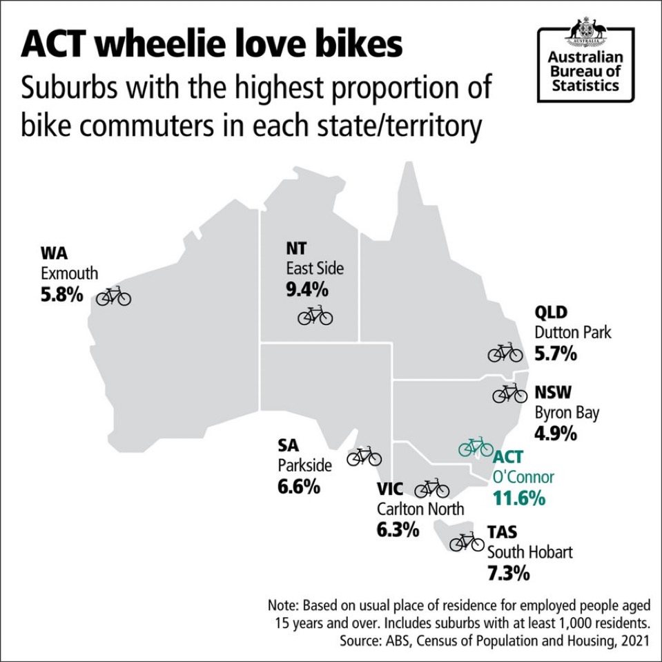
- Already a popular route for people riding, scootering and walking. Many hundreds of people travel the Rivulet Track to get to & from the city each day. This route is the reason South Hobart has the highest rate of commuting by bike in Tassie and among the highest in the country — but at 7% it could be much higher. →
- Relatively low volume & slow vehicle traffic. It’s not a good way to drive for many reasons: one way sections, one lane sections, traffic lights strongly favouring cross streets like Barrack Street, a better option one block over in traffic-flow-optimised Macquarie Street, and so on.
- For all these reasons it’s long been identified by the council and state government as being a key street for active transport and bike lanes have been planned for years — see the timeline below.
Everyone will be safer:
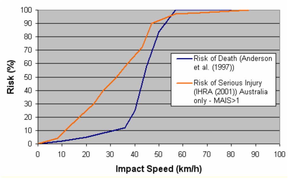
- People will walk along a calmer street with better crossings. Their risk of dying if hit by a car will drop from ~90% at the existing 50 km/h speed limit to ~10% at the new 30 km/h limit. There will be less scooters & bikes on the footpaths too. →
- The bike lanes will be kerbside & protected — this is the safest type of on road bike infrastructure and meets all ages and abilities (AAA) standard. Those less confident riding bikes, older people, kids, people with various disabilities — many more will have the genuine option to ride a bike if they want.
- There will be hook turn boxes to facilitate people on bikes turning right safely at intersections.
- Together with 30 km/h speed limit signs, changes like narrower lanes and slight chicaning due to parking bays on alternating sides should encourage people to drive more slowly.
- Calmer traffic means people in cars are safer too.
Improvements in movement of cars:
- No change to number of traffic lanes aside from removal of separate turning lanes at some intersections.
- More people riding bikes into the city means fewer cars competing for space on Macquarie & Davey Streets.
- Less dependence on a single mode of transport means a more resilient transport network — therefore less gridlock when a vehicle crash blocks a key road.
And more good things:
- The floating bus stop will give people somewhere to wait for the bus that isn’t the footpath, potentially with seating. The freed up space will make it easier for people to walk and roll along the footpath.
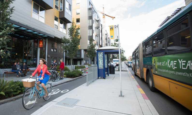
- These changes should be just a first step to making Collins Street a better place for people to enjoy — future opportunities include better public transport facilities, street trees, planter boxes, seating and outdoor dining.
- The tactical approach — enables a quick installation and allows future adjustments for an optimal outcome.
- Many people in the community are strongly supportive — 1300 signed a supporting petition and 150 rode down Collins Street on a Sunday morning to show their support.
The less good
- The bike lanes won’t connect to other parts of the network. The hope has to be they will continue to Argyle & Campbell Streets in the near future. The true benefits of safe bike infrastructure can’t be fully realised until there is a connected network. It’s clear that this is something that Hobart is struggling with — witness Davey Street, Argyle Street and many more.
- Bikes sharing with traffic between Harrington & Murray Streets will not be all ages and abilities standard — even if vehicle speeds become acceptably low the volume of traffic won’t. Essentially, this means less people will feel comfortable riding along Collins Street and ultimately will limit the benefits of the entire project. Careful assessment of this section during the trial will be needed to see whether the compromise here is acceptable.
- Success will mean limitations in the Hobart Rivulet Track become increasingly significant and council will need to address these issues — safer surfaces, more lighting, a better route through the car park, etc. A future upgrade converting the current shared path to separate paths for walking & cycling should be considered in the longer term too. The same applies to related infrastructure like the Bumpy Track.
- Adjusting the timing of traffic signals to suit lower speeds isn’t mentioned in the concept but would be worthwhile investigating.
Community concerns
1. On street car parking
Among the many changes, it’s the potential impacts of reducing on street car parking spaces that is the most common concern raised.
Why remove parking?
Collins Street is essentially four lanes for vehicles — two moving, two parked — with a footpath either side. The footpaths aren’t particularly wide and support:
- People walking, pushing prams, rolling in wheelchairs, scootering, waiting for buses with their luggage and sometimes riding their bikes.
- Infrastructure like parking meters, bins, lamp posts, sign posts, seating, bike racks, outdoor dining furniture and A-frame shop signs.
Realistically it’s only by reallocating some space from the four vehicle lanes that change can occur. The decision then comes down to whether the change is in vehicle parking or vehicle movement — in this case the decision was for parking changes.
So what will the impact be?
The council report states external analysis by consulting firm WSP indicates “the removal of parking bays will not have significant impacts on parking availability in the immediate vicinity of the project“. Their justification for this conclusion includes:
- The demand for the on street parking in the three blocks averages 58% during weekdays. The Harrington-Murray block which is the busiest with the least parking is 79% (which is at the standard target occupancy of 80%).
- Weekday peak occupancy for the 782 spaces in Centrepoint Car Park is 83% meaning there are 130 spaces available even at peak times. This is more than double the 49 on street spaces being removed.
- There’s opportunities for more on street parking nearby that could be repurposed to short-stay parking if monitoring shows it’s required in future.
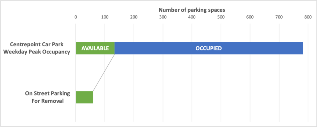
Essentially they’ve concluded the on street parking as it stands isn’t fully utilised, and there’s also more than enough capacity in nearby parking to account for any shortcomings.
The bigger picture
In this particular case independent professional assessment shows the removal of parking won’t have significant impact. However it’s timely to mention the realities of on street parking in Hobart. Cities worldwide are rapidly moving away from prioritising on street parking because parking private cars is not an efficient use of this valuable public land. For example Paris is removing ~70,000 (or about 50%) of their on street parking spaces over a time span of a few years.
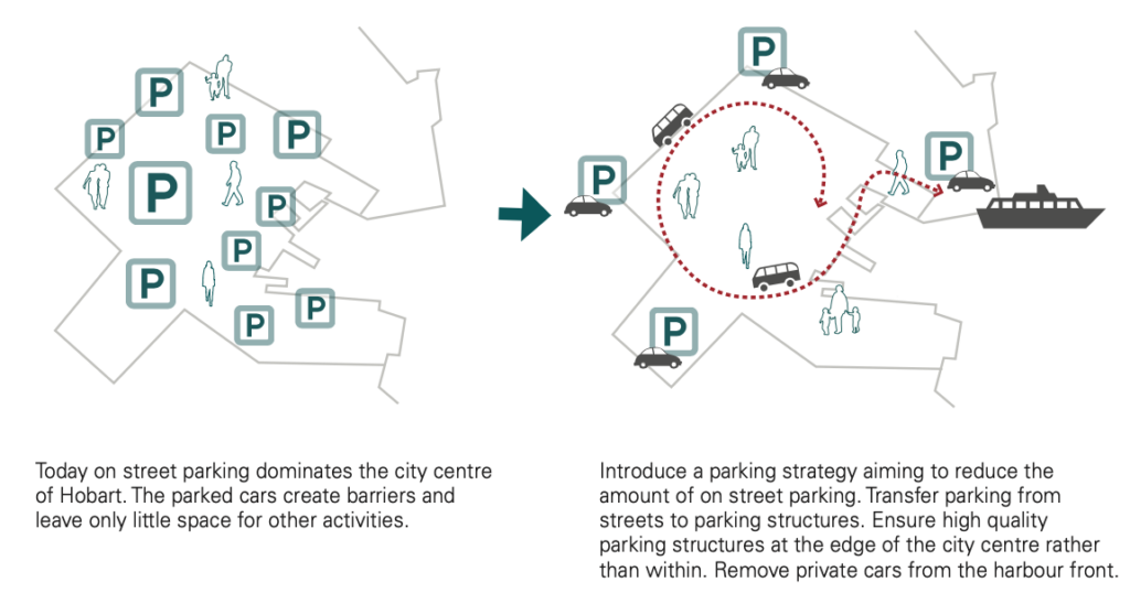
Hobart has traffic congestion and a growing population — parking your car directly outside the shop you’re visiting in the city at any time of day is no longer realistic. And while Hobart hasn’t reacted as rapidly as Paris, the planning here reached that conclusion a long time ago. For example the Gehl Report recommended in 2010 that Hobart should aim to reduce on street parking.
2. Business impacts
Some business owners on Collins Street are concerned that less on street car parking will lead to less customers and less revenue. While it’s understandable to be concerned about change, the proven reality is that making streets better for cycling and walking improves business.
Research in New York showed that shops next to a protected bike lane saw a 49% increase in sales compared to 3% for Manhattan as a whole. Similarly in the UK studies have shown that high street changes aimed at improving cycling and walking increase retail sales by up to 30%. →
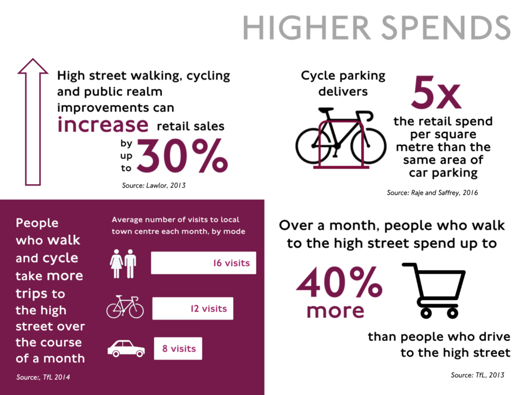
Research shows many other benefits for businesses too. Some examples:
- Retail vacancy was 17% lower after high street and town centre improvements.
- Physically active employees took 27% less sick days.
- 73% of employees who cycle felt it made them more productive at work.
3. Accessibility
People with disabilities which limit their mobility have the right to be able to access businesses and services they need. Some in the community are concerned the planned changes might impact this. However council states they intend to retain 91% of priority kerbside access — this includes accessibility parking bays as well as loading areas. They also state they are engaging with the City Access Advisory Committee to inform the location of additional accessible parking bays in the final design, suggesting accessible parking may in fact increase.
It’s also important to remember many people in the community can’t or don’t drive — people with various disabilities, older people, children & adolescents, people unable to afford to buy & run a car, and so on. Safer walking, riding, scootering & wheeling will improve mobility and therefore accessibility for these people.
4. Council income
Another concern raised has been a potential reduction in City of Hobart income from on street parking payments. In general there’s more important factors at play in decisions about parking than revenue generation. Putting this aside though, there’s a number of reasons the impact shouldn’t be significant:
- The 49 parking spaces being converted to other uses equates to just 1.1% of total paid spaces operated by the council (~2000 on street, >2500 off street).
- It’s likely many people will change their behaviour and park elsewhere. This will help mitigate any income loss.
5. Other concerns
We’ve posted a thread on X addressing a couple of other specific concerns.
Alternative approaches
Let’s consider a couple of variations on the plan.
Alternative 1 — a single direction bike lane on Collins Street
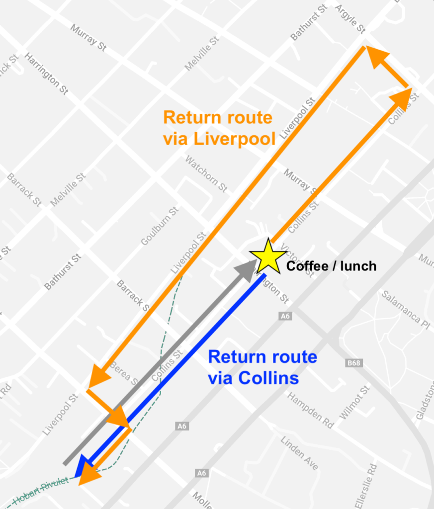
Proposed by some in the community. The idea is a single bike lane along Collins Street with the bike lane in the reverse direction on a nearby street — realistically either Macquarie or Liverpool Streets. The stated benefit is that less on street parking would need to be removed from Collins Street.
Thoughts on this approach:
- Parking changes would be spread across two streets, however the net effect across the CBD would be similar.
- A bike lane on Macquarie Street is unlikely. Planning documents don’t indicate intentions for a bike lane. Recent changes by the state government have removed parking specifically to increase traffic lanes. In reality the space would be better utilised as a dedicated transit lane for a rapid bus network or light rail.
- Which leaves Liverpool Street. It’s essentially the reverse of Collins — parking changes would be similar. However it would be difficult to connect to the Rivulet Track, requiring either a contra-flow (against traffic) bike lane on Molle Street or a bike lane on Barrack Street (a street where high throughput of vehicle traffic is prioritised). Collins Street is flatter too.
- Finally, the one-way system for vehicles in Hobart’s CBD is notoriously tedious to navigate. Replicating it in the bike network would be a failure to learn from past mistakes. →
Alternative 2 — clearways
Another suggestion is that the bike lanes could be made available only during peak commuting times with the lanes converting to on-street parking outside of these times.
Clearways are often used to add capacity for vehicle movements during peak times. They can work well providing there’s a high degree of compliance with not parking at peak times. However it only takes one car left parked too long to stop the whole lane from functioning (this often happens on Sandy Bay Road for example).
As well, using this approach for bikes lanes on Collins Street is different because it’s not flexing additional capacity — from 2 lanes to 3 for example — it’s adding and removing the entire capacity. That means that unless you’re strict about riding your bike to and from the city within the peak hours, you don’t get the safety & confidence benefits the protected bike lanes provide. This would clearly have a significant impact on motivating people who are less confident on their bikes and to a large extent defeats the whole purpose of adding bike lanes in the first place.
Another issue with this approach is a practical one. In order to meet the all ages and abilities standard — which is both appropriate and the plan — the bike lanes need to be protected from vehicles with bollards or similar. It’s difficult to imagine how this could be achieved while then also making the space accessible for vehicles to park in outside of peak commuting times.
Alternative 3 — retaining an on street parking lane
The concept plan removes two parking lanes between Harrington & Murray Streets in order to retain two driving lanes. An alternative approach would be to remove one parking lane and one driving lane.
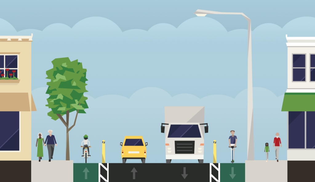
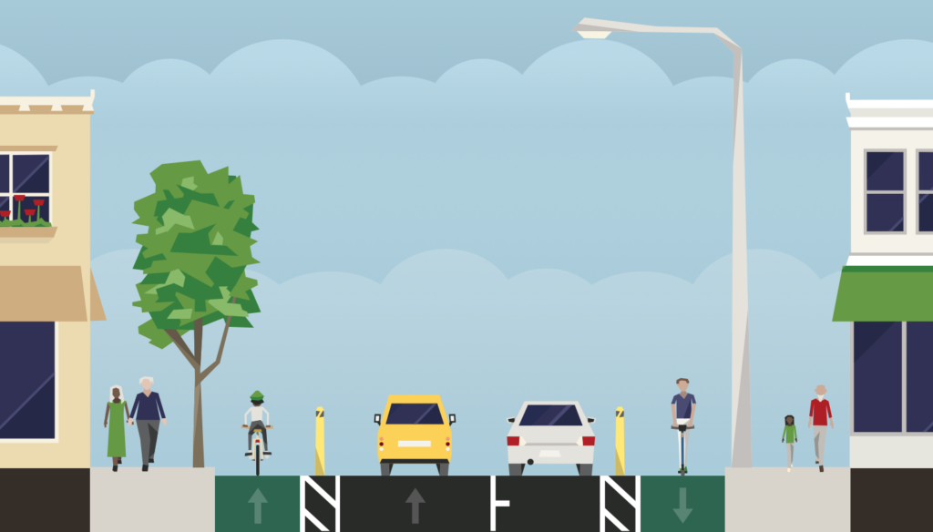
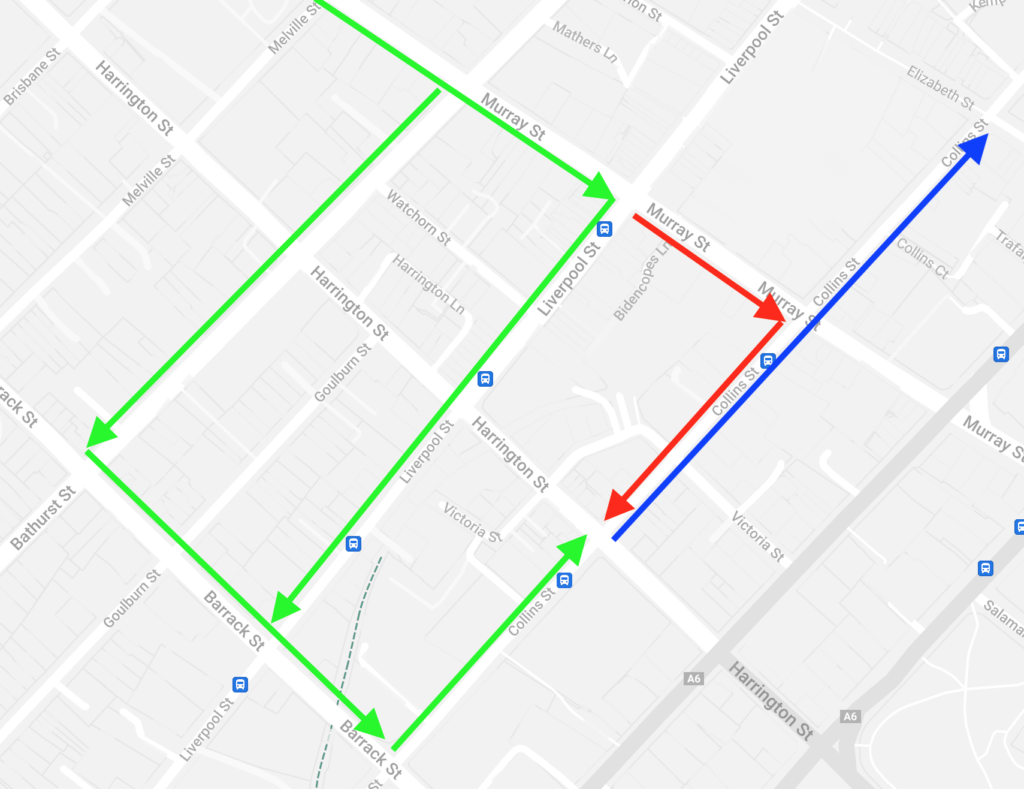
This approach would retain more on street parking. The trade off would be the block becomes one-way. While this is usually not desirable, the next block of Collins Street — Murray to Elizabeth — is already one-way and so the effects are limited. Effectively some Murray Street traffic would need to turn right earlier to use Liverpool or Bathurst Streets. →
This is a legitimate alternative and may well be preferred by the community given the extra on street parking. The changes required might be more than is suitable for a tactical approach but are minimal — essentially a no right turn from Murray Street into Collins Street.
Where’s it at?
City of Hobart will be implementing the changes between Molle Street and Victoria Street over a 6 week period starting on 24 March 2025. Work will mostly occur overnight. Safe pedestrian access will be maintained. There will be some temporary lane closures and reduced speed limits.
Implementation of the section between Victoria Street and Murray Street has been delayed while the council explored options “to retain loading zone and parking opportunities” as per a motion at the November council meeting. The updated design for this section — which removed the southbound protected bike lane and thereby retained parking — was endorsed at the March council meeting. It’s not yet clear when this section will be implemented.
Project timeline
- 31 March 2025 — Councillors endorsed a new design for the section between Victoria and Murrays Streets which removed the southbound protected bike lane.
- 25 March 2025 — A public meeting was held, triggered by a petition lead by a small business group. A substantial majority of the several hundred community members present at the meeting passed the motion “That the meeting supports the Collins Street trial, as endorsed by the City of Hobart on 16 September 2024“. Motions supporting no or less bike lanes were not passed.
- 24 March 2025 — Construction started on the changes between Molle & Victoria Streets.
- 17 March 2025 — The sharrows design was discussed at the Hobart Workshop Committee Meeting.
- 14 October 2024 — City of Hobart councillors voted to reallocate funds from the 2024-25 budget contingency to enable the project to be completed without the state government grant
- 11 October 2024 — The Tasmanian Minister for Transport announced he had directed the Department of State Growth not to proceed with the $170,000 grant
- 17 September 2024 — Planning documents for the proposed Macquarie Point stadium submitted to the Tasmanian Planning Commission reveal an active transport corridor along Collins Street as a key part of the transport plan for the stadium
- 16 September 2024 — City of Hobart councillors voted to endorse the final design
- 15 July 2024 — The Tasmanian Minister for Transport announced a $170,000 grant for construction of the Collins Street tactical cycleway in round 2 of the Better Active Transport Grant program
- May 2024 — City of Hobart councillors voted to proceed to a more detailed design phase involving further community engagement
- 2023 — Central Hobart Plan & Inner Hobart Traffic Network Operations Plan both endorsed with Collins Street part of the cycling network
- 2023 — $30,000 for Collins Street cycleway design — granted to City of Hobart by the Tasmanian government as part of the Better Active Transport in Greater Hobart program
- 2022 — traffic signals installed at the intersection of Collins & Molle Streets
- 2021 — Greater Hobart Cycling Plan endorsed by the state government and four greater Hobart councils which includes extending the all ages and ability bike network along Collins Street
- 2019 — $100,000 for an outbound marked bike lane on Collins Street from Victoria Street to Molle Street — granted to City of Hobart by the Australian government
- 2019 — City of Hobart Annual Plan 2019-20: “Finalise the concept design for improved bicycle connections along Collins Street“
- 2018— City of Hobart Annual Plan 2018-19: “Prepare concept design for improved bicycle connections along Collins Street“
- 2017 — City of Hobart Annual Plan 2017-18: “Prepare concept design for improved bicycle connections along Collins Street“
- 2010 — Gehl Report and City of Hobart’s response the Inner City Action Plan recommend strengthening the connection from the Rivulet track along Collins Street to the city including a bike lane
- 2009 — Hobart Regional Arterial Bicycle Network Plan includes an arterial cycleway on Collins Street
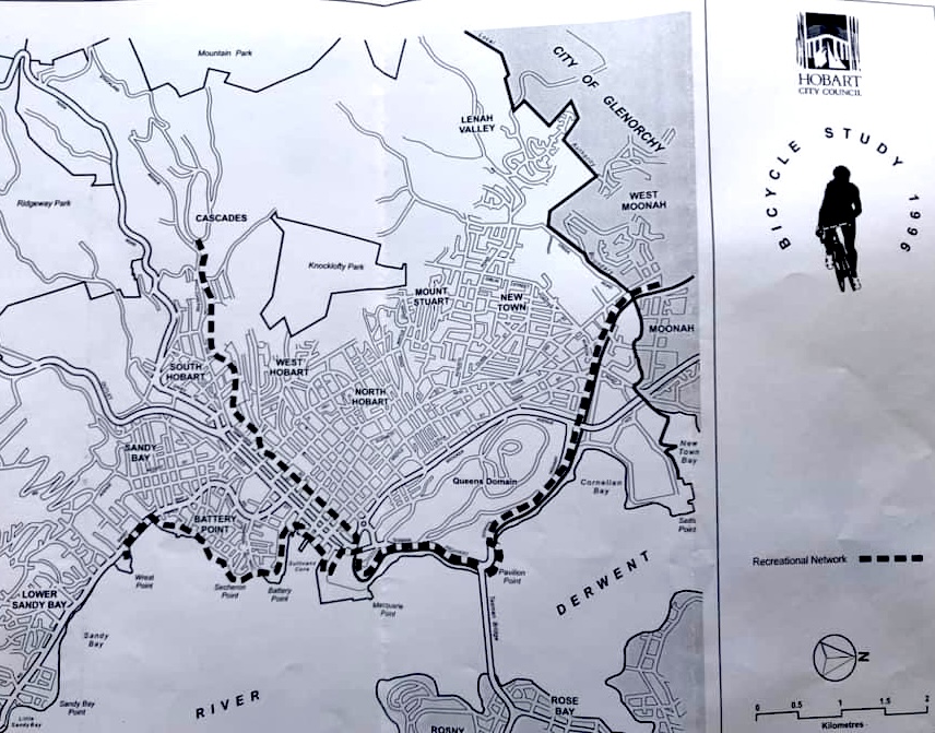
- 1996 — City of Hobart’s Bicycle Study included Collins Street as a key route in a very sparse network:
More info
City of Hobart project page
Final design
Greater Hobart Cycling Plan
I support the Collins St bike lanes. I really hope this gets through–It’s scary trying to share the road with cars who don’t want to share with bikes.
I wonder if it’s a distraction from a more significant issue. The government hasn’t done anything to improve public transport, so it’s like they’re trying to blame bike lanes for not fixing our car dependency. As people are liberated with their cars in Tasmania, without them, they are trapped, except those who live close enough to the inner urban cores and have/will have the option to use active transport and save money.
Bike lanes raise many emotions; sometimes, people already have strong opinions about cyclists. When people are emotional, misinformation is challenging to remedy. This can lead to misunderstandings, make it easy for the government to dodge responsibility for making fundamental changes in transport, and stoke culture wars. So, by stirring up arguments about bike lanes, the government might be hiding the fact that we still don’t have good alternatives to driving everywhere.
I’m really hope this get done. So very dissappointing that the state government gets spooked by a few noisy shop owners.
Total mess,
Poorly designed using examples from cities that have significantly more mature public transport in place.
I am bike rider, having lived and commuted in many cities/countries and honestly I’m blown away with the lack of transparency from this poorly designed excuse of an a persons solo agenda.
Do better Hobart, and remember this is Hobart, not every person has an income stream that lets them buy a 5K ebike to remove the hills that we live in.
Oh and just a quick survey of how many work places have end of journey facilities, and let’s talk retail not the hospital…
Common sense.
Thanks for your comments Ben.
Agreed, Hobart absolutely needs much better public transport. Improving active transport doesn’t prevent this from happening. In fact it helps enable it by offering a solution for the last mile problem.
Bikes are much much cheaper to buy and run than cars — every trip you ride a bike instead of driving saves you money. You can get an e-bike from a reputable bike shop as cheap as $1000 in a sale, $1500 full price. There’s even a new e-bike library in Hobart so you can trial one free before committing. Giving people the option to use bikes improves social equality, it’s the opposite of elitism.
Accurate that not every workplace has end of bike trip facilities. Plenty of places do though, Menzies being another big one. Increasing demand means more will. The company that owns the Telstra Centre on Collins / Argyle added them a few years ago purely because the demand made the investment worthwhile. 188 Collins is looking to add some now too. Retail buildings will inevitably follow suit as demand increases.
You didn’t specifically say what’s poor about the design. It’s a trial though and we’ll all get a chance to suggest improvements.
As for lack of transparency and “a persons solo agenda”, just look at that project timeline!
Could they get more multistorey carparks before they go ahead with the whole project. Hardly enough parking spaces as is and after completion there will be even less. People who work in the city and need to cart tools back and forth can’t after these changes.