City of Hobart has released a discussion paper which is the initial step towards creating a neighbourhood plan for Mount Nelson and Sandy Bay.
The plan will outline how Sandy Bay and Mount Nelson should develop over the next 20 years.
The ideas for better streets
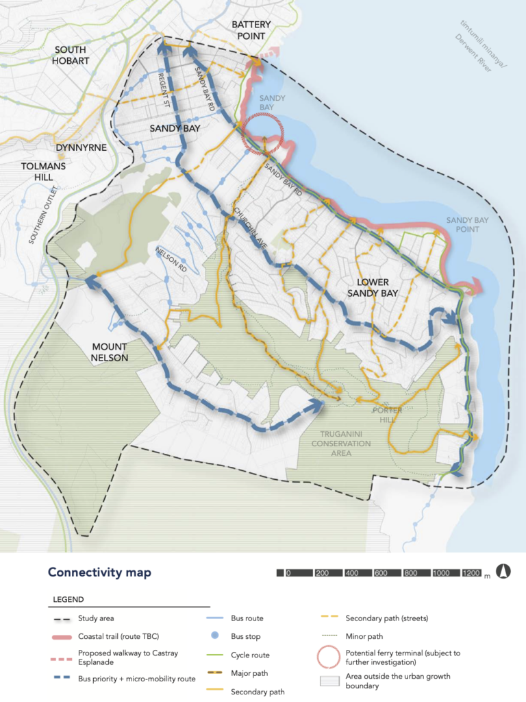
Increase sustainable travel choices (idea 12, page 76):
- Separated bike & micro-mobility path along the entire length of Sandy Bay Road.
- Investigation of dedicated cycle pathways along alternative routes — eg Grosvenor Street, Regent Street, Churchill Avenue.
- Interchange & integration between transport modes — bikes & micro-mobility on public transport, end-of-trip facilities.
- Connections to the proposed coastal walkway from Marieville Esplanade to Castray Esplanade (the walkway itself is outside the plan area).

Improve walkability (idea 13, page 78):
- Wider footpaths with less obstructions, more crossings including raised wombat crossings, pedestrian signage, seats, shade.
- Target areas include Sandy Bay shops, between Sandy Bay Road & Churchill Avenue and between Mount Nelson’s shop & oval/playground.
Prioritise public transport (idea 14, page 79):
- Advocate for bus lanes, more frequent buses, better bus stops, etc.
- Ferry to Sandy Bay with walking & riding connections and secure bike parking.
Create a leafy green urban environment (idea 2, page 44).
Strengthen the local economy & convenience offer (idea 5, page 50) — shops, services & jobs within walking distance.

Our thoughts
The good
- It’s excellent to see a separated cycle & micromobility path planned for the full length of Sandy Bay Road. The current bike lane is inadequate — doesn’t reach the Sandy Bay shops let alone the CBD, not separated, often in the door zone, sometimes on the footpath, sometimes disappears all together. It’s also important to note that the proposed Battery Point coastal walkway wouldn’t be useful for many trips in inner Sandy Bay — such as any trip to the shops, or the popular Fitzroy Place → Albuera St → Sandy Bay Road → Montpelier Retreat route. Both should be built.
- The transport ideas are focused on improving walking, cycling, buses and ferries. The importance of being able to easily switch between modes is noted.
- There’s lots of mention of modern street design approaches — all ages and abilities bike infrastructure, continuous footpaths, wombat crossings and so on.
- There’s recognition of the rapidly increasing use of electric bikes and scooters.
The less good
- The transport connectivity plan could be clearer. What is the difference between a micromobility route and a cycle route? Is a major path just a footpath or would it include a bike lane?
- The transport connectivity plan is not as detailed as would be ideal for a 20 year plan. There should be a detailed cycle network plan for example, with primary, secondary & local cycle routes.
- The timeframe. The discussion paper is an early step in the development of a 20 year plan. Most of these things should be happening already.
- Many ideas — like better footpaths, pedestrian crossings & pedestrian signage — should simply be the default standard across Hobart, already being built routinely.
- There’s lots of noncommittal language —’investigate‘, ‘opportunities‘, ‘advocate for‘. The statement on bus lanes is a good example: ‘investigating measures on a trial basis including temporary initiatives, including incorporating bus lanes where practical‘. Less concrete plan, more aspirational vision.
Where to from here?
Community consultation on the discussion paper closed on 1 January 2024. Feedback received will inform the development of the Draft Neighbourhood Plan.
More info
Mount Nelson and Sandy Bay Neighbourhood Plan on City of Hobart’s Your Say site
News item on the discussion paper — Bicycle Network Tasmania